If you blow a big hole in the Himalayas, will the northwest become a land of fish and rice?
The windward slope of the Himalayas is the place with the most precipitation in the world. The annual precipitation exceeds 10,000 mm, which is about 10 meters. And to the north of the Himalayas, the whole place is barren and completely desert.
Many people are thinking, if I blow a big hole in the Qinghai-Tibet Plateau or the Himalayas and put water vapor in it, will the climate of the whole Qinghai-Tibet Plateau and the whole northwest change fundamentally and become a land of plenty?
Text | Wei Ke Associate Research Fellow lasg
This article was reprinted from WeChat WeChat official account "Yi Xi Club" (ID: yixiclub). The original article was first published on June 7, 2021. The original title was "If we blow a big hole in the Himalayas, will the whole northwest become a land of fish and rice?" | Wei Ke’s 771st Speaker does not represent the viewpoint of a think tank.
Why is the northwest unusually dry?
Hello, I’m Wei Ke, from lasg. The Institute of Atmospheric Physics was formerly the Institute of Meteorology, Academia Sinica during the Republic of China, and its first director was Mr. Zhu Kezhen, so the research on climate in China has a history of more than 90 years since then.
Our institute of atmospheric physics has an observation station in the Gobi desert, which is about 200 kilometers away from Dunhuang city. It is very dry around this observation station, as it was a few days ago.
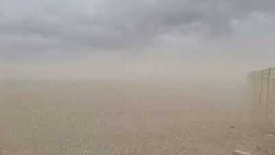
On May 24th, this observatory in Gobi ushered in the nth sandstorm this year, where n is a relatively large number.
If the wind speed will decrease a little in a few days and wait until summer, then it is likely to be like this.
As you can see, whether it’s spring or summer, no matter how full of green is in our eastern region,This place seems to be deserted forever, very, very dry.
Let me make some comparisons here. For example, as many of us know, Yan ‘an and Yulin are above the Loess Plateau and seem to be relatively dry areas. But in fact, from the annual average precipitation, we can see that the upper left picture shows the precipitation in Yan’ an, with an annual average of more than 500 mm. The average annual precipitation in Beijing is close to 600 mm, so Yan ‘an is not much different from Beijing.
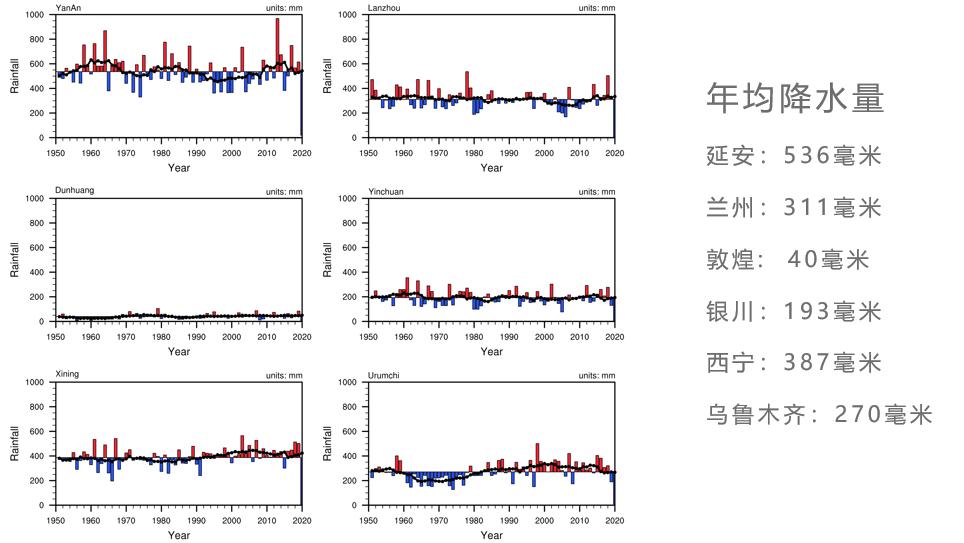
But when we compare it, we know that the annual precipitation in Dunhuang is about 40 mm, which is less than one day’s precipitation in the eastern region. It is normal for a rainstorm in the eastern region to reach 100 mm. Take a look again. Yinchuan is 193mm, Xining is 387mm and Urumqi is 270mm. These places are very dry.
Recently, some people may have seen a news that the Mu Us Desert in northern Shaanxi seems to be disappearing soon. But in fact, the average annual precipitation in places like Maowusu is close to 400 mm, and ecological restoration in those places is possible.The annual precipitation in Dunhuang is less than 50 mm, so it is basically impossible to turn these places into a place of full of green.
If you want to know the climate of China, it is actually very simple. You can basically divide China into two parts by drawing a line from the northeast to the southwest.
Southeast China is a land of plenty, with a large population, active economy and a lot of precipitation. The whole northwest region is relatively dry, and its economic activity is not as good as that of the eastern region. This is a very typical climate dividing line.This climatic dividing line is often called "Hu Huanyong Line", which basically runs along the dividing line with an average annual precipitation of 400 mm..
If we push the dividing line further west, we will find that there is an area where the average annual precipitation does not exceed 200 mm at most, which is in this orange area.
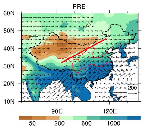
▲ Average annual precipitation
Comparing the precipitation in South China, the average annual precipitation can often reach 1600 mm, which is very large.
It’s just that there is little precipitation. The evaporation in this place is very large.There is basically no cloudy weather all year round, and the sun is direct, which is very suitable for evaporation, so the annual evaporation is very large, basically above 1000 mm.
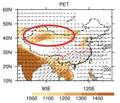
▲ Annual potential evaporation
In Dunhuang and other places I circled in red, the evaporation is even close to 2000 mm. Then let’s think about the balance of water-the precipitation is 200 mm, but it is possible to evaporate 2000 mm. It is strange that this place is not dry.
Why is this place so dry? In fact, the reason is very simple.Geographically, this place is inland and lacks water vapor. Water vapor comes from the ocean, but it is very far from any ocean.
If we want to find a place on the earth, which is the farthest from the ocean, I guess it must be in the northwest. Whether it is from the Pacific Ocean in the east, the Indian Ocean in the south, the Atlantic Ocean in the west or the Arctic Ocean in the north, it is very far away. So even if there is water vapor flow and atmospheric circulation, it can’t come in the middle.
We made such a numerical simulation. If there is only land, but there is no Qinghai-Tibet Plateau, no Pamirs Plateau and no barrier of these landforms, the simulated climate is the same, and there is very little precipitation in Central Asia.
This arrow represents the wind direction, which means the direction of water vapor transportation. We don’t think the water vapor from the Indian Ocean will go directly to the north, but it will turn east when it walks and turn to the eastern part of our country.
Another reason, we call it the foehn effect in meteorology.The distribution of water vapor on the earth satisfies relatively simple physical laws, which we call Clabolon-Clausius equation. The higher the temperature, the closer it is to the ground, the more water vapor can be contained in the air. The lower the temperature and the higher the distance from the ground, the lower the water vapor content in the atmosphere.
If there is a mountain, on the windward side of the mountain, the wind comes with water vapor and then climbs gradually. In the process of climbing, the temperature of the air gradually decreases, and soon it will condense to form rainfall, and then precipitation will form on the windward slope.
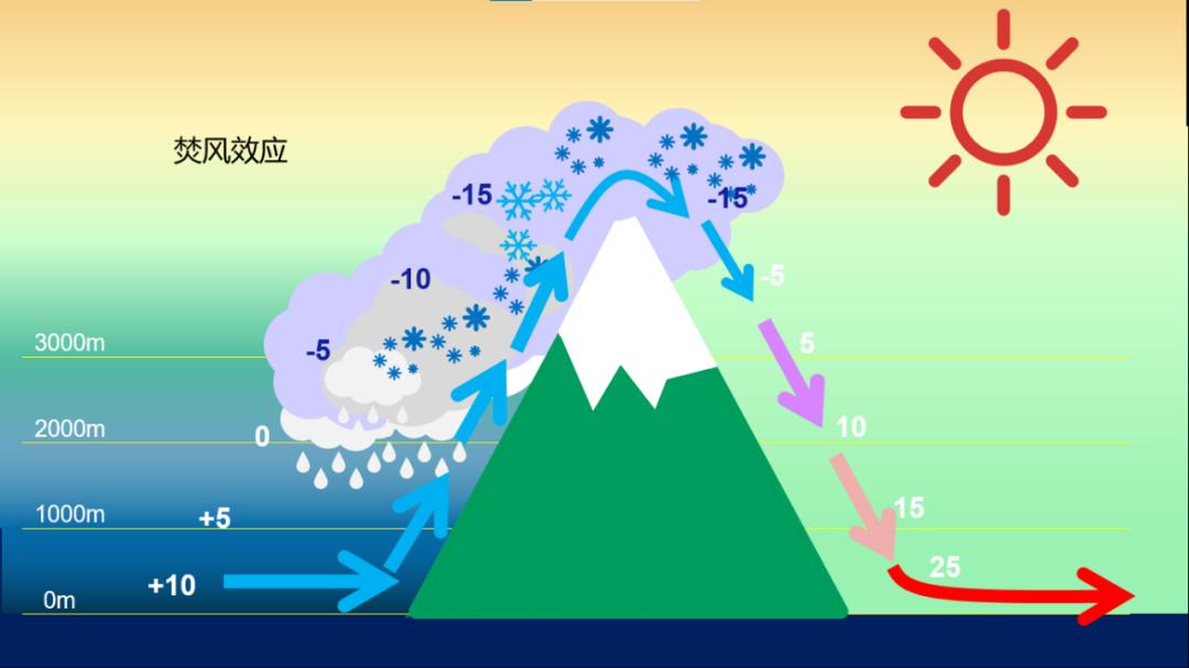
Because the water has been lowered in the process of climbing the mountain, it becomes dry air after climbing the mountain. So we can see that,In the windward slope, it is generally very humid, while in the leeward slope, dry and hot valleys often form.
The whole northwest of China is surrounded by mountains.The Qinghai-Tibet Plateau in the south, the Pamirs and Tianshan Mountains in the west, and the mountains in the north. The east is very, very far from the sea, so if there is airflow over the mountains, no matter where you come from, it will definitely dry up there.
If the air flows from the Indian Ocean to the northwest, then you can think about which mountains it will cross-Himalayas, Gangdise Mountains, Tanggula Mountains and Karakorum Mountains. This series of mountains is turned over, and each mountain is like a dehydrator.
The airflow rushed directly to the height of more than 6,000 meters in the sky, and it was continuously dehydrated during the mountain climbing. The remaining water vapor continued to take off when passing through the next mountain range until it reached the northwest, and it became very dry, and no water vapor could fall down.
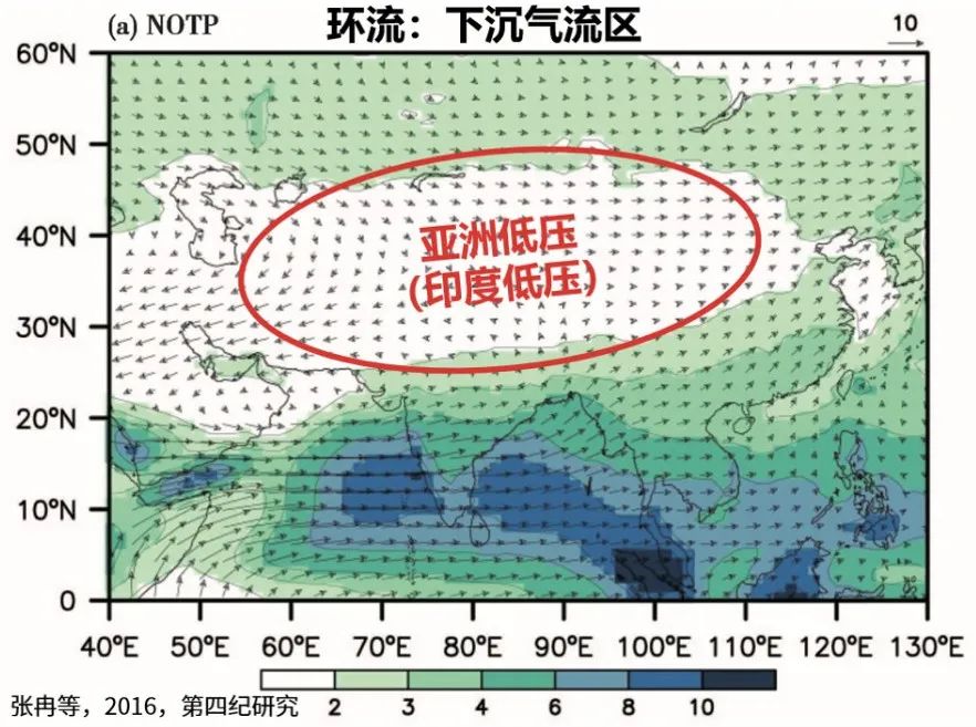
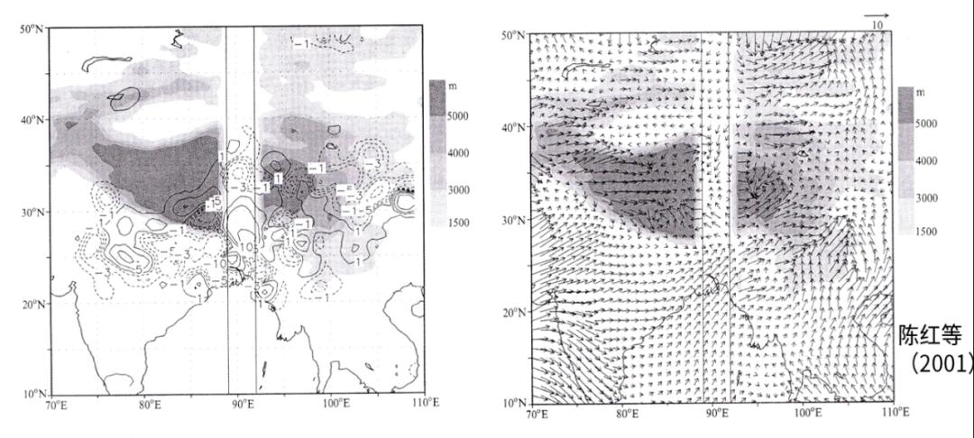
On the other hand, there is the role of atmospheric circulation.. If our land and sea distribution does not change, one side is Eurasia, the other side is the Pacific Ocean, and the south is the Qinghai-Tibet Plateau, at this time, a high pressure center will definitely form in the high altitude of this place in the northwest, just like the dark area I gave in the picture.
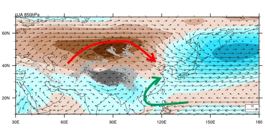
Where the high pressure area is located, the air sinks, and when it sinks, it will easily make the clouds dissipate, and the sinking will form a warming.So even if there is a little cloud in that place, it will dissipate in the process of sinking and become cloudless weather. Therefore, the northwest region is basically the region with the strongest solar radiation and the richest solar energy resources in our country.
Then these points are combined, far away from the ocean, deep inland and surrounded by mountains-the foehn effect after the formation of mountains makes this place very dry.
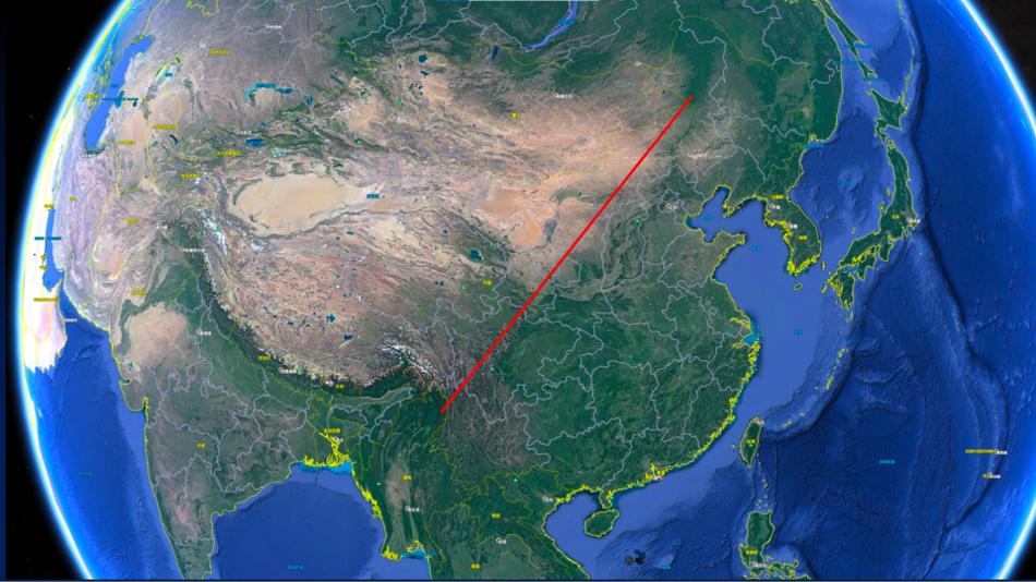
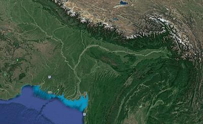
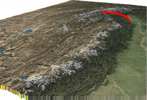
Let’s compare. This picture is along the north and south of the Himalayas. We can see that in the south of the Himalayas, it is a green country. The whole Indochina Peninsula, as well as South Asia, is very humid and the precipitation is very high.
▲ North and South Himalayas
The windward slope of the Himalayas is the place with the most precipitation in the world. The annual precipitation exceeds 10,000 mm, which is about 10 meters.And to the north of the Himalayas, the whole place is barren and completely desert.
In addition, if you look at the contrast between the north and the south of Tianshan Mountain, you can see that it is humid on the windward side of Tianshan Mountain, but it is very dry and deserted on the leeward side.
▲ North and South Tianshan Mountains
If we match the terrain and precipitation in the whole country, we can see that,The precipitation in the eastern part of our country comes from the Pacific Ocean. In the process of westward advancement, the water vapor in the Pacific Ocean first forms precipitation in Nanling, Lingnan and the area south of Wuyishan in South China.. The average annual precipitation in these places can reach 1600 mm.
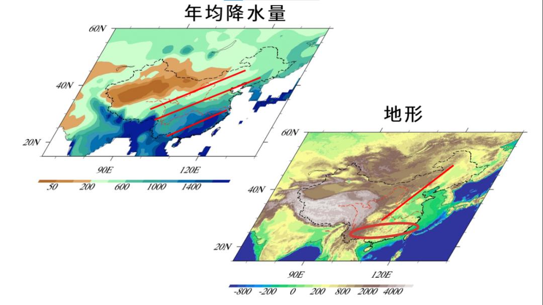
After dehydration of a series of ups and downs in Nanling and Wuyishan,In the Yangtze river basin, the average annual precipitation will drop to 1000 ~ 1200mm.. These mountains in Nanling are not particularly high, only a few hundred meters at the highest, so this dehydration effect can be achieved.
Then when we go west from the first step to the second step of our country, we have to cross Wushan, Yunnan-Guizhou Plateau and Taihang Mountains. After this series of mountain dehydration,In places like Shaanxi and Shanxi, the average annual precipitation drops to 500-700 mm.
Note that even when the precipitation drops to 500 and 700 in this place, we haven’t encountered a particularly decent mountain. For example, Huashan Mountain, the highest mountain in the Five Mountains, is only over 2,000 meters above sea level, which is less than halfway up the Qinghai-Tibet Plateau, because the average ground height of the Qinghai-Tibet Plateau is above 4,500 meters. You can imagine how dry this water vapor will become when it goes west and passes through a series of mountains.
one
How long is the history of drought in northwest China?
Northwest China is not so dry just now. If we look at the history of northwest China, we will know that the dry history of this place is very long. We know that there are coal and oil in many places in Xinjiang, which shows that the ecological conditions in this place were very good before, and there may have been forests and lake bottoms.
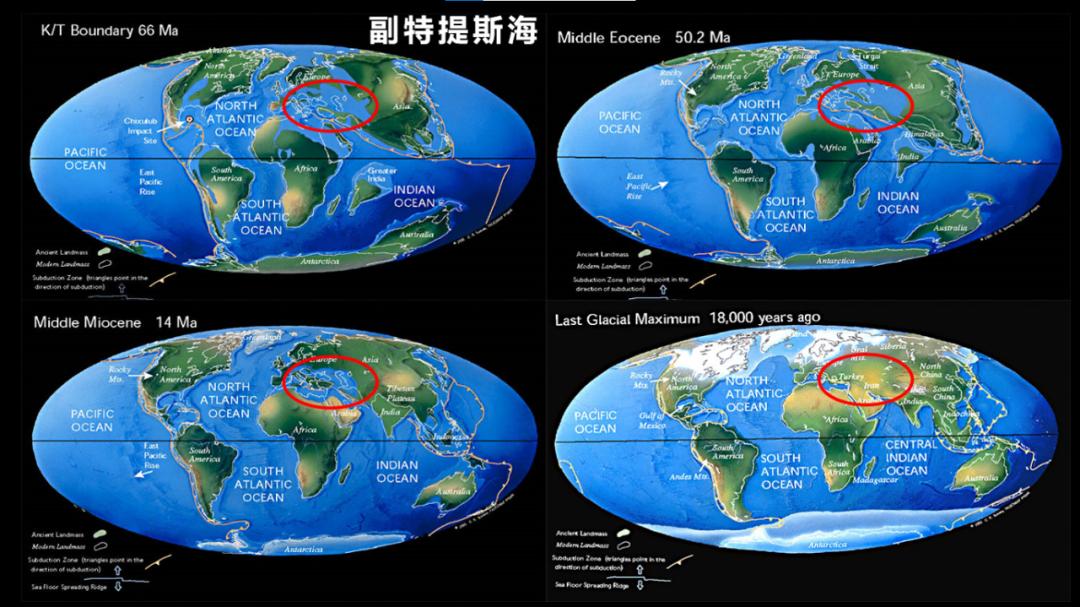
In fact, this place is a place called the Deputy Tethys Sea in history. This sea has gradually shrunk and become the present Mediterranean, while the western region has gradually retreated from the coastal area to the inland area.
When that place becomes dry, the wind will scrape out the soil on the ground and then fall down in other places, forming the loess plateau with a very large area in our country. Therefore, by investigating the history of the Loess Plateau, we can know how long the history of drought in northwest China is.According to the current research, the Loess Plateau has a history of about 22 million years, so the drought in the northwest has such a long history.
With the uplift of the Himalayas and the uplift of the whole Qinghai-Tibet Plateau, the whole northwest has become drier. Some numerical simulations made by scientists confirm this process.
For example, if we assume that there is only land, but there is no Qinghai-Tibet Plateau and the whole Pamirs, we will gradually increase the altitude, the scale of the Qinghai-Tibet Plateau will gradually increase, and the altitude will gradually increase, and the height is only 20%, 40%, 60% and 80% of the current height. Then we will simulate its climate.
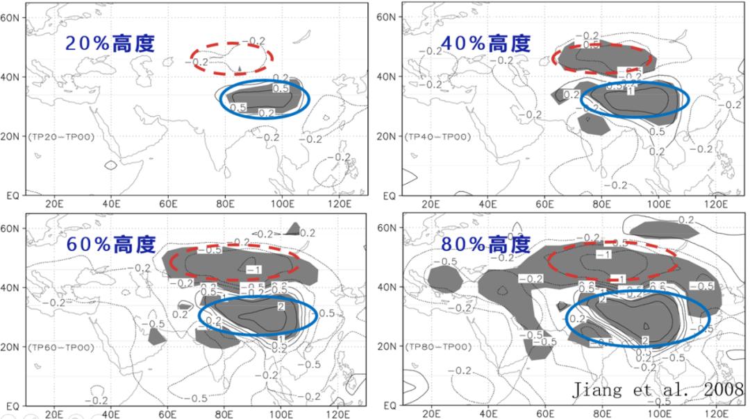
It is found that during the uplift of the Qinghai-Tibet Plateau, the precipitation in Central Asia and northwest China depicted by the red circle is gradually decreasing, while the precipitation in the southern region is gradually increasing. That is to say, that place is already in the inland area, which is very dry, and the uplift of the Qinghai-Tibet Plateau has reduced the precipitation in that place and made it drier.
2
Blow a big hole in the Himalayas
So many people are thinking,If I blow a big hole in the Qinghai-Tibet Plateau or the Himalayas and put water vapor in it, will the climate of the whole Qinghai-Tibet Plateau and the whole northwest change fundamentally and become a land of plenty?
In fact, scientists have thought about this idea. In a speech recorded by Mr. Li Ruihuan in 1995, it was mentioned that some scientists also mentioned this idea, including Mr. Qian Xuesen and Mr. Qian Sanqiang.
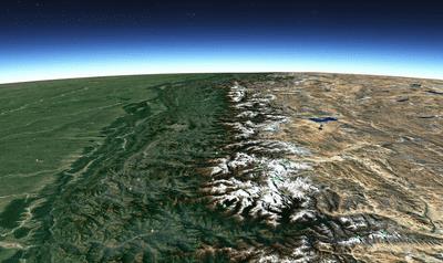
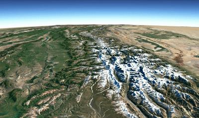
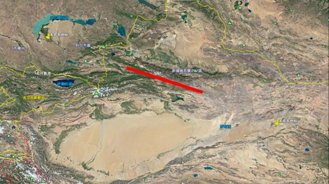
The scientific community has had a serious discussion on this topic.Although the Himalayas is a long mountain range, it actually has many mountain passes and many small openings, one of which is the entire Yarlung Zangbo River Grand Canyon, which looks like this.
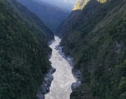
▲ Natural water vapor channel-Yarlung Zangbo Grand Canyon
The Yarlung Zangbo River flows from west to east, turns through the Grand Canyon, and then flows south and out of the border.
This is a natural incision.Can this cut bring about a better climate in the whole Qinghai-Tibet Plateau? The answer is no.
Even if there is such a hole, it has not brought about fundamental climate change in the whole Qinghai-Tibet Plateau.The only influence is that there are many towering snow-capped mountains on both sides of the Yarlung Zangbo River Grand Canyon, and the scale and number of snow-capped mountains are more than those in other places.
Many people may say that this cut in the canyon looks a little small, and we want to make a bigger one. Then if you open your mouth a little wider, will it fundamentally change the climate? Scientists have done some numerical simulations about this problem. We simulated a big hole-about 1000 kilometers wide, 1000 kilometers wide, and driving from Beijing is almost to Wuhan; It is about 1000 meters deep.
The result is that after opening such a hole, there will be some increase in precipitation in the southern and central areas of this hole, but the precipitation in the northern part of this hole will decrease.
The reason is very simple. After the opening, the dry air from the north will go south along the opening and meet the air from the south in the opening, thus increasing some precipitation in the southern and central regions, while the precipitation in the northern region will decrease due to the influence of the dry air. This does not seem to bring more water resources to the whole northwest region.
Then someone may have said, can you drive a little deeper? It seems that you have only dug 4000 meters. Can you dig further? OK, our researchers have done some numerical simulations.
If an incision is made, it is 300 kilometers wide, as far as driving from Beijing to Shijiazhuang, and the depth reaches zero meters above sea level, that is, it is as deep as the sea level. From the Bay of Bengal, whether Bangladesh agrees or not, Nepal agrees or not, no matter what, it will push all the way from the seaside there to dig through the Qinghai-Tibet Plateau.
The simulation results are basically similar to the previous results, with precipitation increasing in the southern part of the passage and still decreasing in the northern part.The reason is simple: dry air from the north came in. Then this gives us a revelation: we may shake mountains easily, but it is difficult to shake the whole atmospheric circulation, and the whole circulation will not change fundamentally.
The reason why Kaizi can’t change the climate of the Qinghai-Tibet Plateau and northwest China is that even if such a hole is opened, it can’t change the root cause of drought in northwest China.First, it is far from any ocean; Second, the mountains are all around, and any airflow over the mountains will sink, which will form a warming, and the warming will become very dry.
There is another point. Even if there are no mountains, as long as there is a normal distribution of land and sea in Eurasia and the Pacific Ocean, a high-pressure area will be formed in this place, and the high-pressure area is a sinking airflow.
Last year, we wrote some popular science articles in Voice of Chinese Academy of Sciences, discussing with you why the proposal of Himalayan mountain mouth is not reliable. At this time, many people contacted us and said that you might have opened your mouth in a wrong position. It is said that the water vapor in the northwest of China does not come from the south, does not pass through the Qinghai-Tibet Plateau, but passes through the Pamirs from the west. So you shouldn’t open your mouth in the south, you should open it in the west, and make a big hole in the Pamirs, which may make the northwest moist.
And opening from the west has many advantages over opening from the south, one of which is opening in our country.
Why? There is an Ili Valley area in the northwest of our country, which is basically the area with the best environment in the northwest. We can see from this picture that it is a trumpet-shaped terrain, which opens to the west, allowing water vapor from the west to come in, and then gradually gathers along this trumpet-shaped mouth to form precipitation here.Because the mountains over there are very high, they not only converge, but also rise, forming a very good ecological environment and climate environment in the Ili Valley.
The average annual precipitation here can reach about 400 ~ 500mm, and even 600mm in some places, and there are 50mm and 100mm precipitation around, which is simply a paradise.
The opening they said is at this intersection. Open the middle place. In fact, let’s zoom in and have a look. Central Asia is very far away from the Atlantic Ocean, the Mediterranean Sea and so on, so there are already many deserts in West Asia itself. For example, the west side of the five Central Asian countries is the famous red desert and black desert. These arid areas.
The reason why Central Asia can form a little wet place is that the five Central Asian countries near China are windward slopes of Pamirs, and the terrain of this place rises directly from one or two kilometers above sea level to four or five kilometers, with very steep terrain uplift.
In the process of this uplift, even if the air is unusually dry, it can form some precipitation after such a large altitude change and strong dehydration. Therefore, the capitals of the five Central Asian countries are basically located at the bottom of the windward slope, and the environment is not bad.
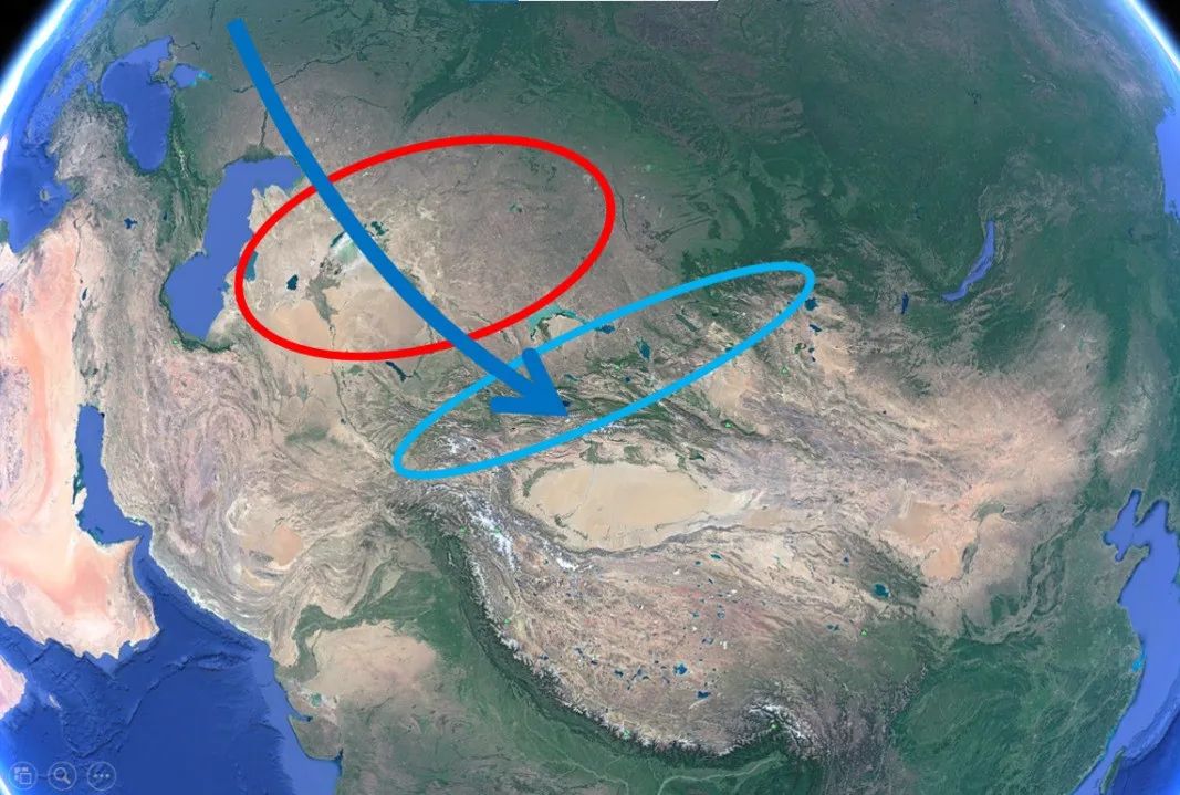
If we shovel the whole Pamirs, the windward slope here will disappear. As long as the windward slope disappears, the precipitation in this place will disappear, so it is very likely that the rare wet areas of the five Central Asian countries will all disappear and Central Asia will become a desert.
Even if water vapor enters China, we will find that our place is a basin, with Junggar Basin in the north and Tarim Basin in the south. The elevations of both basins are lower than those around. The average elevation of Tarim Basin is 1,100 meters, while the average elevation of Junggar Basin is only over 600 meters.
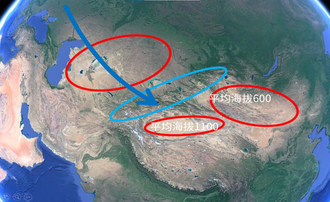
You removed the windward slope over there, and after the water vapor came over, you still had to cross a low highland, and then it sank. You destroyed other people’s climate and there was still no precipitation in your place.Because it is still affected by the foehn, it will not change the climate here.
In fact, scientists have done some other numerical simulations. For example, in this picture, if there is no terrain, there is no Qinghai-Tibet high, there is no Pamirs, there are no Tianshan Mountains and Altai Mountains, and there are no mountains. As a result of the simulation, we can see that this white area is an arid area, and this place in northwest Central Asia, including Mongolia, is a very arid area.
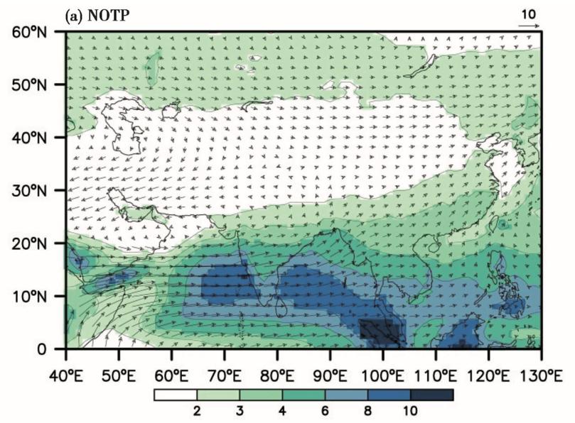
▲ Zhang Ran et al., 2016, Quaternary research.
three
Is it getting warm and wet in the northwest?
Since last year, the topic of northwest becoming warm and humid has been brought up again. Some people say that our northwest has become more humid, and this place will soon become like the Tang Dynasty. If we go further, we will catch up with the Zhou Dynasty, and our whole northwest will become a relatively humid place.

We can see that these big media, Xinhua News Agency, Global Times, and especially Global Times, use this headline-"The real event, the cold and arid northwest is getting warmer and wetter". Everyone suddenly had an illusory idea, as if the ecology of northwest China had undergone a fundamental change in recent years. According to this change, that place will get better and better.
Many people think it is a new change, but in fact it is an old topic. In 2002 and 2003, scientists have already discussed this topic. The famous geographer Mr. Shi Yafeng has analyzed some changes that have taken place in the northwest. In some places, precipitation has increased slightly, and the amount of water in lakes has increased in some places. In some places, there will be some seasonal floods and so on.He pointed out the fundamental problem, that is, the climate in northwest China has its own limitations, so it is not appropriate to exaggerate its role.
We also made some analysis on the specific changes.The reason why many people think that the northwest is becoming humid is because they have observed an increase in precipitation in the northwest.. For example, the picture at the top left shows the annual precipitation changes from the 1960s to the present. The dark line curve shows its trend, and we can see that the precipitation has indeed increased in the past so many years.
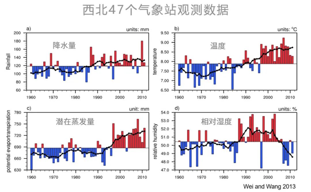
In the past, the average precipitation was about 100 mm, and it increased to about 120 mm, which is a great increase.
However, we noticed that during this period, the temperature in the northwest increased faster than that in other parts of the world because of the global temperature increase. The picture on the upper right shows that the temperature in the northwest is increasing, and the increasing speed is two to three times faster than that in the eastern part of China.
The increase in temperature has brought about a great change, that is, the potential evaporation is also increasing rapidly.The increase of potential evaporation is greater than that of precipitation. This means that with the increase of precipitation, this place will become even drier.
Let’s look at the change of relative humidity in the picture at the bottom right: from 1980s to 1990s, the relative humidity in that place increased because of the increase of precipitation. However, from the 1990s to the present, because of the increase of temperature and potential evaporation, the relative humidity in that place has gradually decreased and become drier.
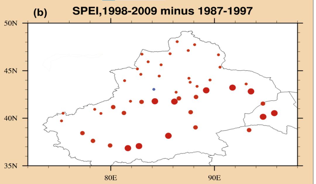
This is the drought index we analyzed. Red means getting drier, blue means getting wetter, and the bigger the red dot, the more serious the drought is. We see that among so many observation stations in the northwest, only one station has been slightly wetted, and all other stations have become drier.
Let’s compare the dry and wet changes in other different areas. If this dry and wet index is positive, it means that this place is getting drier and drier. We see that the dry-wet index of Tarim Basin has always maintained a relatively high value, about 1000, which means that the evaporation in this place is more than 1000 mm than the precipitation, and this value is still increasing, and this trend has been going up.
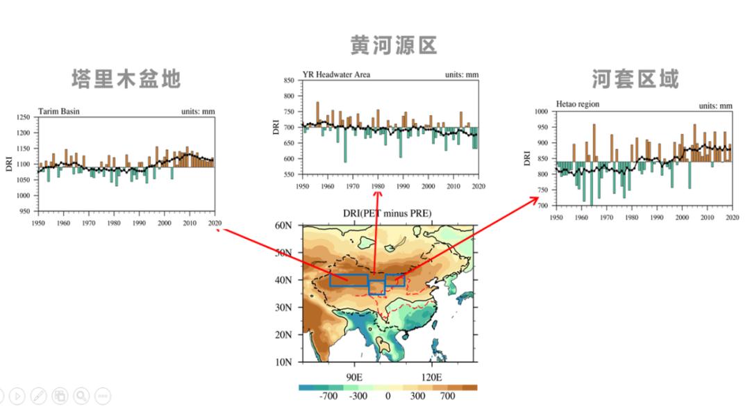
Hetao area is also a dry area, and its value is also positive, and it has been rising and becoming drier. The only place in the source region of the Yellow River seems to have a slight trend of drought relief, but this trend is not particularly obvious.
Let’s compare the changes between drought and humidity in our country. This shaded area indicates that these areas are becoming more arid. From H to SH, it means from humid to semi-humid, from SH to SA means from semi-humid to semi-arid, and from SA to A means from semi-arid to drought.
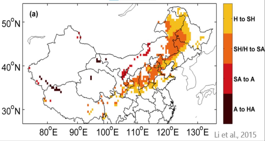
We see that in the northern part of our country, from the whole northeast to north China, and to the eastern part of the northwest, a large range of local droughts are still developing, and the droughts in these places have become more serious.Therefore, we can’t be optimistic that some areas in the northwest have increased precipitation and improved ecology, so we think that we seem to have entered the next stage, and the northwest seems to be getting wet.
In fact, our country as a whole is experiencing the development of drought, so we should deeply understand what the ecological environment changes in different places are because of. Many places, including northern Shaanxi and Hetao areas, including the Mu Us Desert, have enough precipitation, which is generally close to 400 mm, or more than 400 mm. As long as people don’t destroy it, the ecology in these places will gradually recover. Therefore, our various measures of returning farmland to forests and grasslands will change the ecology of that place.
However, if the precipitation in the northwest is 200 mm, it can’t be restored by returning farmland to forests and grasslands. The precipitation in that place is not enough to support the growth of trees or decent grass. It is a desert.
In other places, the mountains have become wetter, and more trees will be seen on the top of the mountain, or grass will flourish. This is probably because the glaciers on the mountains have melted.The melting of glaciers is due to global warming, which is not a good thing, but a sign of the decline of the whole ecosystem. What you see is that the place turns green, but what is actually hidden is a bigger crisis.
One more thing, the increase of precipitation in some places in northwest China is not like "spring rain moistens like oil", but in the form of heavy rain, two heavy rains suddenly, and then this year’s precipitation ended, so it not only did not alleviate the drought, but brought floods.
Like Dunhuang in July last year, where the annual precipitation was less than 40 mm, two rainstorms closed the Mogao Grottoes for several days, and the impact on this place was not positive.
The whole northwest is so dry, we told you the reasons and the changes in recent years. Some people may feel desperate, and that place seems to have no hope of change.
This is definitely not the case. This place is full of hope.We can change its ecology in various ways.For example, even in such a arid area of Xinjiang, the agricultural irrigation in many places is like the one on the left. The water from the snow-capped mountains is flooded, and a canal brings in the water from one end and comes out from the other, and the land is watered.
However, the way of flood irrigation is very wasteful, and it will be completely sunburned in two days, because the evaporation in that place is very large. There are a lot of water resources from snow-capped mountains in these places, and it would be a great waste if this way is adopted.
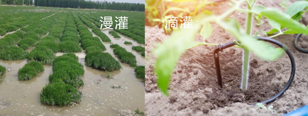
We all know that many melons and fruits in the northwest are very good, just because the environment there is enough to produce such an effect. To develop agriculture, if we can improve the whole water-saving irrigation technology, such as the application of drip irrigation and sprinkler irrigation, and strengthen the investment in this part of agriculture, this place will definitely change a lot.
There are still many people who think that there seems to be no vitality in the desert in the northwest. In fact, if the water resources in that place can be used reasonably, it can also glow with certain vitality in this place.
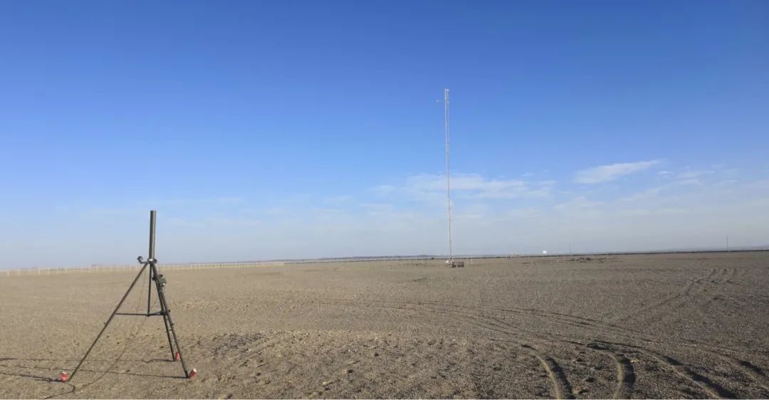
This photo is the scene in the desert that I took around the observatory mentioned at the beginning. We still found many small plants growing in the desert, and that place is not barren.
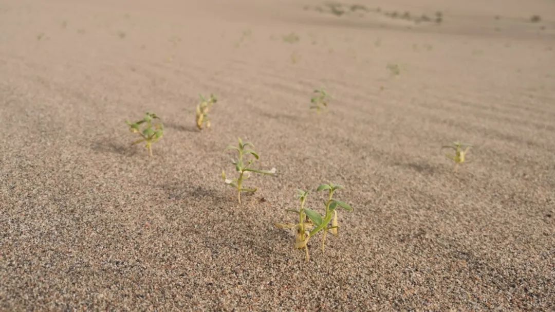
This little video shows that butterflies are still flying in the very arid Gobi Desert, so this place hides a lot of vitality and has its own ecosystem.Therefore, for such a very fragile area, our protection is the first, and development is the second.

Original title: "If you blow a big hole in the Himalayas, will the northwest become a land of fish and rice?" 》
Read the original text